Storm Bay
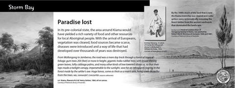
In its pre-colonial state, the area around Kiama would have yielded a rich variety of food and other resources for local Aboriginal people. With the arrival of Europeans, vegetation was cleared, food sources became scarce, diseases were introduced and a way of life that had developed over thousands of years was destroyed.
From Wollongong to Jamberoo, the road was a mere day track through a forest of tropical foliage; gum trees 200 [feet] or more in height, gigantic India-rubber trees with broad shining green leaves, lofty cabbage palms, and many other kinds of tree towered above us, so that their tops made a twilight canopy, impenetrable to the sunlight, save for an infrequent clearing in the forest made by the settler's axe. Huge lianas, some as thick as a man's arm, hung sown snakelike from the trees. MILL MANAGER'S DAUGHTER (source unknown)
This plaque is 1 of many found around the district. The plaques describe the history of their locations. They were commissioned by Kiama Council in 2009.
If you had seen them around, you are welcome to have a look at the collection of plaques in the district.
Location
South Pacific Ocean, Kiama 2533 View Map
-34.6724716,150.8565524
South Pacific Ocean ,
Kiama 2533
South Pacific Ocean ,
Kiama 2533
Storm Bay
Photo Gallery